Precip – Rain Totals & Weather
- 4.7
- Rating
- 100.00K
- Installs
- Free
- Price

 Analysis by App-foxy
Weather apps usually try to answer one broad question: “What will the weather be like?” Precip – Rain, Snow & Weather takes a narrower and more practical approach. It is built around rainfall and snowfall totals for specific points on a map, which makes it useful when a general city forecast feels too vague. I found the idea especially appealing for people who plan around outdoor conditions rather than simply checking whether an icon shows sun or clouds.
Developed by Precipitation Inc., this free weather app sits in a useful space between a standard forecast and a more focused precipitation tool. It is rated for Everyone, works on Android versions starting with 6.0, and the current version is 3.0.1. The app has reached over 100 thousand installs, with a 4.4 average from around 2.7 thousand ratings and 636 written reviews. Those figures suggest a healthy level of interest, but my decision to recommend it comes more from the way its map-centered design can answer location-specific questions.
I would not treat it as a complete replacement for every weather service. If you need a long daily forecast, broad climate information, severe-weather notices, or a full collection of lifestyle features, a traditional weather app may still be more convenient. Precip is at its best when the amount of rain or snow at a particular place matters more than a general forecast for the nearest town.
You May Also Like

 Blood Strike: 2.5 Anniversary
Blood Strike’s Loadouts Turn Every Drop Into a Tactical Gamble
A close look at Blood Strike’s custom loadouts: how fast access to signature weapons reshapes its battle royale rhythm, rewards preparation, and narrows the gap between fights.

 Pandora - Music & Podcasts
Pandora’s Music Is Easy to Start, but Harder to Recover
Pandora’s strength is its low-effort path from a seed to a station. Its weak spot is how much confidence it asks you to place in connection, setup, and quiet recovery.

 8 Ball Pool
 Is Built on Rivalries, Rematches, and Routine
A close look at the rivalries, rematches, shared routines, and unanswered safety questions that turn a quick pool match into a persistent mobile community.

 Samsung Music
’s Quiet Strength Is Playing What You Already Own
Its reach comes less from spectacle than from dependable access to a personal library. That simplicity is both the app’s strongest retention engine and its ceiling.

 AccuWeather: Weather Radar
AccuWeather Review: A Quick, Clear Forecast for Everyday Decisions
For everyday plans, the best forecast is the one you can understand quickly. AccuWeather makes rain timing, radar, and local conditions easy to act on, with a few trade-offs.

 Hill Climb Racing
Why Hill Climb Racing Still Turns Crashes Into One More Run
A tiny car, a bumpy hill and one more upgrade: Hill Climb Racing keeps resurfacing because its simple chaos makes every near-miss feel personal.
More From Our News Desk
View All News


How Precip works when the exact location matters
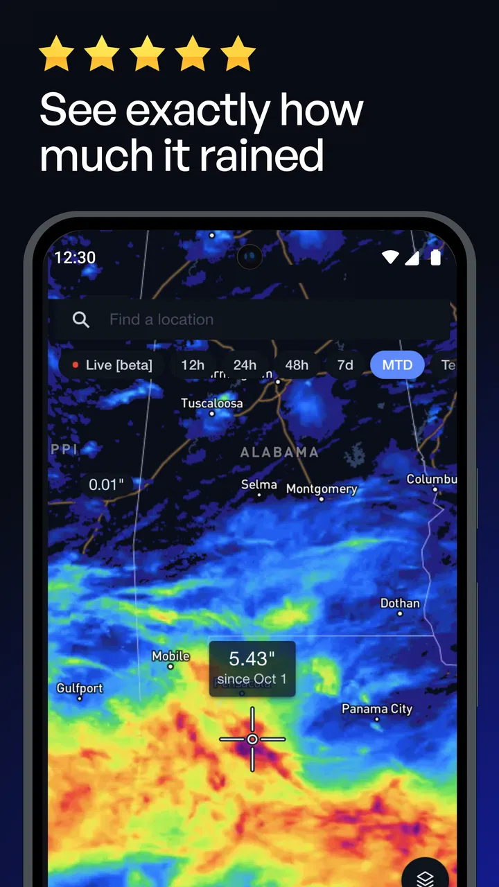
I focus here on what changes when a forecast is tied to a particular place rather than a broad city area. In practice, I find that the map is most useful as a way to compare destinations before committing to a plan, especially when nearby locations may not share the same precipitation outlook.
Readable information instead of a crowded forecast screen
The central concept is straightforward: choose a point on a map and examine expected rainfall or snowfall totals there. That focus can make the experience easier to understand than a conventional weather app filled with hourly rows, icons, wind details, humidity readings, alerts, and unrelated extras. When I want to know whether a trailhead, sports field, campsite, or work site may receive meaningful precipitation, a map-based view feels more direct than scrolling through a city forecast.
That simplicity also supports better decision-making for people who find dense weather dashboards tiring. A user who prefers visual information can think in terms of places rather than a long text forecast. Someone who has difficulty processing several changing measurements at once may appreciate being able to concentrate on one question: how much rain or snow is expected at this location?
There is an important trade-off, though. A map does not automatically make information accessible to everyone. Maps can be visually busy, and interpreting color differences may be difficult for users with low vision or color-vision differences. I would use the app alongside a more text-oriented weather source if precise reading of map shading is uncomfortable. The app’s strongest idea is also the place where its presentation needs the most care: location-based precipitation is useful only when the result is easy to distinguish and interpret.
For general navigation, the app’s narrow purpose is an advantage. I do not have to work through a long list of unrelated weather categories before reaching precipitation information. On the other hand, people who rely on large text, strong contrast, screen readers, or highly customizable display settings should judge the actual interface on their device before making it their only weather reference. The experience may vary depending on screen size, operating-system settings, and personal needs.
Why the map changes the way I plan
The most useful shift is that I can compare places instead of accepting the forecast for one named city as a substitute for every nearby area. That matters in regions where weather changes over short distances. A neighborhood, hill, valley, or coastal edge may not experience the same precipitation as the place used by a conventional local forecast.
One practical workflow is to check the destination first, then inspect the route or nearby alternatives. For a weekend walk, I might compare the trail entrance with a lower location and a backup destination. For a youth sports event, I could look at the field rather than the town center. This does not guarantee perfect certainty, but it encourages a more realistic question: what conditions are likely where I will actually be?
A second useful habit is to use the app before making a commitment, not only immediately before leaving. If a planned activity depends on dry ground, fresh snow, or manageable accumulation, checking several points can reveal whether the destination is likely to differ from home. I would still recheck close to departure because precipitation forecasts change, but the map gives me a better starting point than a single generalized forecast.
Motor and sensory considerations in everyday use
Map interaction can be comfortable for people who prefer tapping and dragging over typing. Selecting a point may reduce the need to enter complicated addresses, especially when the destination is a recognizable outdoor location. This can help users who find keyboard input slow or physically demanding. It is also convenient when I am already looking at a map and want to investigate a nearby place without building a detailed search phrase.
At the same time, maps often require precise gestures. Pinching, dragging, tapping a small area, and correcting an accidental selection can be frustrating for people with tremors, limited dexterity, or difficulty maintaining steady touch. A large phone screen may make this easier than a small one, while a crowded map can make it harder. I would avoid judging the app solely by its concept; the real question is whether selecting a location feels reliable with your usual touch settings.
For users who are sensitive to visual overload, the focused purpose is encouraging, but the map still deserves attention. Precipitation layers can involve changing shades and visual patterns, and a user may need to pause to understand what the display is communicating. I would not rely on color alone when making a safety-sensitive decision. If the forecast looks ambiguous, I would confirm it with a text-based source or official local information.
People with hearing loss are not placed at an obvious disadvantage by a weather tool whose main value is visual location information, but that does not mean every important warning is covered. Weather decisions should not depend on one app’s presentation style. Users who need audible, vibrating, or highly prominent alerts should verify whether their broader weather setup meets those needs rather than assuming the map view is a complete notification system.
Situational access: when the app earns a place on my phone
The best everyday scenario is a changeable outdoor plan. Imagine I am leaving home for a cycling route and the destination is outside the nearest city. A normal forecast may tell me that the region has a chance of rain, but that wording does not tell me whether the route’s far end is likely to receive substantially more precipitation. I can inspect the destination and nearby points in Precip, then decide whether to shorten the ride, leave earlier, or choose an alternative.
Snow planning is another strong use case. A driver, property manager, event organizer, or traveler may care about accumulation at one specific address rather than a broad regional label. Looking at a point on the map can support a more informed comparison between locations. I would still treat the information as guidance, especially when road safety is involved, but the ability to focus on a precise place is more useful than a generic “snow nearby” description.
The app can also help people whose routines are shaped by mobility or sensory needs. If wet paths, slippery surfaces, or snow accumulation create extra difficulty, checking a destination before traveling may help avoid an unpleasant or unsafe trip. This is not a substitute for checking accessibility at the destination itself, but it adds a weather-specific step to planning. Someone using a wheelchair, walker, cane, or mobility scooter may reasonably care about precipitation totals more than a decorative daily weather summary.
For caregivers and families, a location-focused check can be useful before arranging outdoor activities. I might compare a playground, a school field, and an indoor backup location rather than relying on the forecast for my home. That makes the app less about curiosity and more about reducing avoidable surprises.
It is also helpful for work that moves between locations. A delivery worker, gardener, photographer, construction worker, or outdoor instructor may need to think about several sites during the same day. The map approach supports quick place-by-place checking. The limitation is that repeated manual inspection can become tiring if the user needs a full schedule, route planning, or a detailed hourly breakdown. In that situation, a broader weather service may be the more efficient companion.
Where the usual weather alternatives are better
Most mainstream weather apps are designed as all-purpose information hubs. They often make it easy to see current conditions, hourly changes, multi-day outlooks, wind, temperature, and alerts in one familiar flow. That breadth is valuable when I am dressing for work, planning a commute, or deciding whether to carry an umbrella. Precip takes a different route by concentrating attention on precipitation totals at selected map locations.
I prefer Precip when the question is spatial: which place is wetter, snowier, or more suitable for an outdoor plan? I prefer a conventional forecast app when the question is temporal: what will the next few hours feel like, and how will temperature or wind change through the day? Using both types can make sense, but users who want one app to do everything may find Precip too specialized.
There is also a difference in cognitive load. A broad weather app can overwhelm some users with options, while a specialized map can feel calmer. Yet a map can introduce its own burden if the user cannot easily read the visual scale or select an exact point. The better choice depends on whether you process information more comfortably through a location view or through clearly labeled text and timelines.
Remaining barriers and practical limitations
The first barrier is interpretation. A precipitation total is not the same as a complete description of conditions. Two places with similar totals may have very different travel experiences depending on timing, temperature, wind, drainage, terrain, and surface conditions. For snow in particular, the effect on roads and paths can depend on more than the total alone. I see the app as a focused planning aid, not a final authority for hazardous travel.
The second barrier is the possibility of uncertainty at small scales. A pinpoint map view feels precise, but weather itself does not always behave with pinpoint precision. I would avoid treating a selected location as a promise. When the decision involves an event, a long drive, or personal safety, I would compare the app’s result with official warnings and a more complete forecast.
The third issue is cost structure. The app is free to download, but in-app purchases are listed from $14.99 to $369.99 per item. That is a wide range, so I would pay close attention to the purchase screen and understand what is included before spending anything. For a casual user who only wants occasional precipitation checks, the free experience may be enough, while a frequent or professional user should evaluate whether any paid option genuinely improves their workflow.
Another consideration is device compatibility. Support begins with Android 6.0, which makes the app available to many older devices, but an older phone may still provide a less comfortable map experience because of its screen size, performance, or touch response. Users with accessibility needs should test zooming, selection, text readability, and any system-level assistance they normally use. I would not assume that technical compatibility automatically means a comfortable experience.
People who need dependable access while driving should plan before starting the trip rather than attempting to interact with a map on the move. The app can inform a decision at home or during a safe stop, but it should not encourage distracted phone use. Likewise, anyone with limited data access or unreliable connectivity should check how well the app fits their circumstances before depending on it in a remote area.
Small habits that make the focused design more useful
I get more value from the app when I compare at least two meaningful points instead of checking only the destination. A home location, the actual destination, and one nearby alternative can tell a more useful story than a single number. This is particularly helpful for outdoor plans near changes in elevation or around large geographic features.
I also separate “how much precipitation” from “can I safely travel?” The first question is where Precip feels most relevant. The second requires broader context. Keeping those questions separate prevents the attractive precision of a map pin from creating false confidence.
For people with visual or motor challenges, I would set up the phone before the weather decision becomes urgent. Increase system text size if needed, use the largest comfortable display, and practice selecting a location when there is no pressure. If map colors are difficult to distinguish, maintain a second source with readable text. This preparation is more reliable than trying to solve an accessibility problem during a storm or just before leaving.
I would also save the app for decisions where location truly changes the answer. Checking it repeatedly for ordinary errands may add unnecessary effort compared with a simple daily forecast. Using the specialized tool selectively keeps its strength clear and avoids turning every weather check into a map exercise.
Who should try it, and who should skip it
I recommend trying Precip if you regularly plan hikes, outdoor work, sports, travel, snow-related activities, or visits to places that are not well represented by a city-center forecast. It is especially promising for users who want to compare several locations and who find a map more intuitive than a long forecast list.
I would be more cautious if you need a highly accessible text-first interface, detailed hourly planning, strong emergency communication, or a complete weather dashboard in one place. Users who cannot comfortably distinguish map layers or perform precise touch gestures may prefer a different service, even if Precip’s underlying idea is attractive. The same is true for anyone who wants a simple glance at temperature and wind rather than a location-based precipitation investigation.
The purchase range is another reason to be selective. Since the app is free to start, I would install it and test the core workflow before considering any optional spending. That lets me answer the important personal questions: Can I read the map comfortably? Can I select the places I care about? Does the result help me make decisions that my regular weather app leaves unclear?
A thoughtful verdict for different abilities and contexts
Precipitation Inc. has made a focused weather app with a clear practical identity. Its map-centered approach can make rainfall and snowfall planning more relevant to the place I will actually visit, rather than the nearest broad forecast area. I find that valuable for outdoor routines, changing local conditions, and people who need to think carefully about wet or snowy surfaces.
Its inclusive potential comes from that focus: fewer unrelated details can mean less clutter, and location-based checking can support more deliberate planning. But the map is not automatically accessible. Visual interpretation, precise touch interaction, and the limits of precipitation estimates can still create barriers. I would pair it with a text-friendly or official source whenever safety, emergency information, or personal accessibility needs are involved.
My final view is positive but specific. Precip is worth trying as a specialized precipitation companion, not as an unquestioned replacement for a full weather service. If the central question in your day is “How much rain or snow is likely at this exact place?”, it offers a more suitable starting point than many general-purpose alternatives. If your priority is a complete forecast that is effortless to read, navigate, and act on in every situation, another app may serve you better.
FAQs for Precip – Rain Totals & Weather
01What features does Precip offer for weather tracking?
Precip provides real-time weather updates, including detailed forecasts for rain and snow. It offers radar maps, severe weather alerts, and customizable notifications. Users can also check hourly and weekly forecasts, making it a comprehensive tool for planning daily activities or trips based on weather conditions.
02Is Precip available for both Android and iOS devices?
Yes, Precip is available for download on both Android and iOS platforms. Users can find it on the Google Play Store and the Apple App Store, ensuring compatibility with a wide range of smartphones and tablets, and providing convenient access to weather updates on the go.
03Does Precip require a subscription for full access?
Precip offers a free version with essential features, but for an ad-free experience and access to advanced features like detailed radar maps and personalized notifications, users may opt for a premium subscription. This allows users to tailor their experience based on their specific weather tracking needs.
04How accurate are the weather forecasts provided by Precip?
Precip utilizes data from reliable meteorological sources to ensure high accuracy in its weather forecasts. It continuously updates information to reflect changing weather patterns, providing users with the most current and precise weather predictions, which is crucial for effective planning and safety.
05Can users customize notifications on Precip?
Yes, users can customize notifications to receive alerts about specific weather conditions, such as rain, snow, or severe weather warnings. This feature allows users to stay informed and prepared for any changes in the weather, tailored to their preferences and location.
Pros
- Accurate local weather forecasts.
- User-friendly interface for easy navigation.
- Real-time precipitation alerts.
- Customizable notification settings.
- Interactive radar maps for detailed view.
Cons
- Requires stable internet connection.
- Some features locked behind paywall.
- Ads can be intrusive at times.
- Occasional data refresh delays.
- Limited language support available.

Precip – Rain Totals & Weather
Gallery